Coastline of India (Revised)
Table of Contents
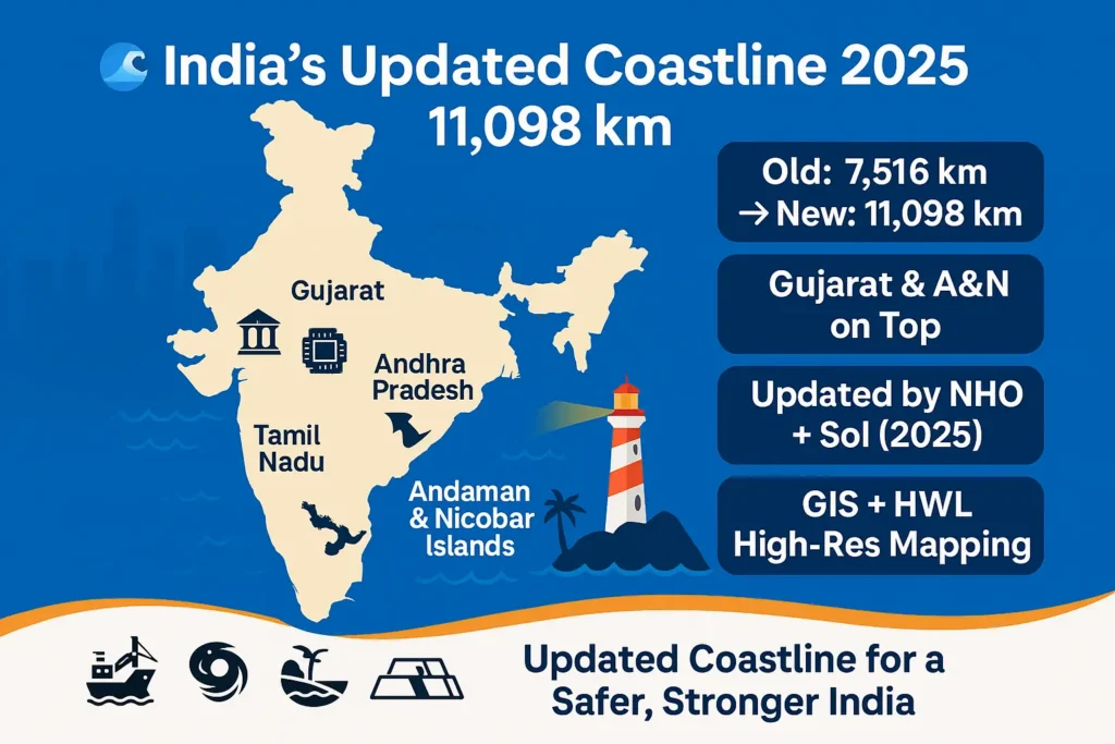
The coastline of India one of the most asked topics in APPSC, UPSC, and SSC Geography has undergone a major official revision. According to a 2025 assessment by the National Hydrographic Office (NHO) and Survey of India (SoI), India’s coastline has been re-measured from 7,516.6 km to 11,098.81 km using high-resolution GIS and updated High-Water Line (HWL) data.
The revision now provides more accurate planning for ports, coastal infrastructure, tourism zones, and disaster management along India’s maritime boundary.
Why Was the Coastline of India Revised?
The National Security Council Secretariat (NSCS) issued new guidelines to reassess the coastline using:
- High-resolution satellite imagery
- Latest High-Water Line (HWL) mapping
- Modern GIS software
- Detailed ground verification by SoI
The updated coastline values were accepted by the Coastal Protection and Development Advisory Committee (CPDAC) and notified by the Ministry of Ports, Shipping and Waterways (MoPSW) on 29 April 2025.
Updated State-wise Coastline of India (2025 Revision)
| State / UT | Old Coastline (km) | Revised Coastline (km) |
|---|---|---|
| Gujarat | 1,214.70 | 2,340.62 |
| Tamil Nadu | 906.90 | 1,068.69 |
| Andhra Pradesh | 973.70 | 1,053.07 |
| Maharashtra | 652.60 | 877.97 |
| West Bengal | 157.50 | 721.02 |
| Kerala | 569.70 | 600.15 |
| Odisha | 476.40 | 574.71 |
| Karnataka | 280.00 | 343.30 |
| Goa | 160.50 | 193.95 |
| Daman & Diu | 54.38 | — |
| Andaman & Nicobar Islands | 1,962.00 | 3,083.50 |
| Lakshadweep | 132.00 | 144.80 |
| Puducherry | 30.60 | 42.65 |
| Total (India) | 7,516.6 km | 11,098.81 km |
Which Indian State Has the Longest Coastline Now?
- Andaman & Nicobar Islands – 3,083.50 km
- Gujarat – 2,340.62 km
- Tamil Nadu – 1,068.69 km
- Andhra Pradesh – 1,053.07 km
This is a major change, as Andhra Pradesh shifted to 3rd position earlier, but now stands 4th after A&N and Gujarat updates.
Why the New Coastline Measurement Matters (Exam Key Points)
The updated India coastline length helps in:
1. Better Planning & Development
- New port locations
- Coastal tourism zones
- Blue economy expansion
- Marine fisheries planning
2. Improved Disaster Management
- Cyclone preparedness
- Flood modelling
- Erosion mapping
- Coastal vulnerability assessments
3. Stronger Maritime Security
- EEZ management
- Territorial waters monitoring
- Coastal patrol optimisation
4. Accurate Environmental Regulation
- Baseline data for conservation
- Better mapping for marine biodiversity
Does the New Coastline Affect CRZ Regulations?
No. The revised coastline length does NOT change Coastal Regulation Zone rules because:
- CRZ boundaries depend only on the High Tide Line (HTL)
- HTL mapping is done using high-resolution aerial photography
- National Centre for Sustainable Coastal Management (NCSCM), Chennai continues to determine CRZ jurisdiction
Meaning of Coastline – Exam Definition
Coastline Meaning:
The coastline is the boundary line where land meets the sea, measured along the High-Water Line (HWL).
Why it varies?
Because the coast has creeks, bays, river mouths, and curves that become visible at high resolution.
Implications of India Having a Long Coastline
Strategic & Economic Implications
- Strengthens India’s Blue Economy
- Enhances port-led development under Sagarmala
- Boosts coastal fisheries and livelihoods
- Improves trade connectivity
Security & Environment Implications
- Requires strong coastal surveillance
- Increases need for disaster management
- Greater focus on mangrove and coral protection
👉 Go to Daily Current Affairs Section
FAQs on the Coastline of India
What is the coastline of India as per the latest revision?
India’s coastline is now 11,098.81 km (2025), revised from 7,516.6 km.
Which state has the longest coastline in India?
Andaman & Nicobar Islands, followed by Gujarat.
Why did India re-measure its coastline?
To use accurate GIS data, new HWL measurements, and update maritime planning.
What is coastline in simple words?
The line where land meets the sea.
Does the new coastline affect CRZ rules?
No. CRZ is based on High Tide Line (HTL), not coastline length.
Which country has the longest coastline in the world?
Canada, approx. 202,080 km.
Reference: Official Document , PIB