National Highways Green Cover Index 2025-26
- National Highways Green Cover Index 2025-26 is India’s first satellite-based audit of green cover along national highways.
- The assessment was released by NHAI in collaboration with ISRO-NRSC.
- It covers about 30,000 km of highways across 24 states.
- Resourcesat-2/2A LISS-IV imagery was used for chlorophyll-based vegetation mapping.
- Assam ranked first with 53.16% GCI, while Andhra Pradesh ranked 11th with 40.23%.
- A dedicated Bhuvan NH-GCI portal has been launched for kilometre-wise monitoring.
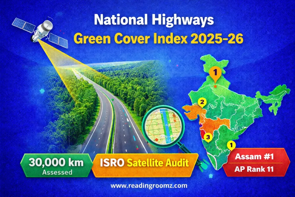
The Union Government has taken a major step toward technology-driven environmental monitoring with the launch of the National Highways Green Cover Index 2025-26. The National Highways Authority of India (NHAI), in collaboration with the National Remote Sensing Centre (NRSC) of ISRO, has released the first satellite-based audit of green cover along National Highways.
This initiative provides a scientific and transparent assessment of roadside vegetation, helping policymakers monitor the implementation of the Green Highways Policy (2015).
What is the National Highways Green Cover Index 2025-26?
The National Highways Green Cover Index 2025-26 is a satellite-based metric used to measure vegetation cover along India’s National Highways.
It estimates the percentage of land covered by greenery within the Right of Way (RoW) of highways. The index is calculated kilometre-wise on both sides of highways, allowing officials to identify canopy gaps and plan targeted plantation drives.
Note: The index is calculated using satellite-based chlorophyll detection, making it an objective and data-driven measure of green cover.
Technology Used in the Green Cover Audit
The National Highways Green Cover Index 2025-26 uses advanced satellite technology developed by ISRO.
| Feature | Details |
|---|---|
| Implementing Agency | NHAI |
| Technical Partner | ISRO – NRSC |
| Satellite Used | Resourcesat-2 / Resourcesat-2A |
| Sensor | LISS-IV |
| Image Resolution | 5 meters |
| Accuracy | ~90% match with ground survey |
High-resolution satellite imagery allows authorities to map vegetation along highways with high precision.
Coverage of the Green Cover Assessment
The first cycle of the National Highways Green Cover Index 2025-26 covers a large portion of India’s highway network.
| Parameter | Details |
|---|---|
| Highways Covered | ~30,000 km |
| States Covered | 24 |
| Phase | Operation & Maintenance Phase |
| Assessment Period | July – December 2024 |
This assessment helps track the implementation progress of the Green Highways Policy launched in 2015.
Bhuvan NH-GCI Portal Launched
To improve transparency, a dedicated GIS portal has been launched on ISRO’s Bhuvan platform.
Key Features
- Kilometer-wise highway vegetation data
- Identification of canopy gaps
- Separate monitoring for left and right sides of highways
- Support for targeted plantation programs
The portal enables real-time monitoring and better planning for highway greening initiatives.
Andhra Pradesh Performance in Green Cover Index
According to the National Highways Green Cover Index 2025-26 report, Andhra Pradesh recorded a cumulative Avenue Green Cover Index of 40.23%.
| Parameter | Value |
|---|---|
| State | Andhra Pradesh |
| Green Cover Index | 40.23% |
| National Rank | 11th out of 24 states |
| Projects Evaluated | 17 |
| Highway Length | 1,339.74 km |
| Area Analysed | 66.58 sq km |
Note: Andhra Pradesh ranks between Rajasthan (40.72%) and Uttarakhand (39.78%).
Top 5 States in National Highways Green Cover Index 2025-26
| Rank | State | Green Cover Index |
|---|---|---|
| 1 | Assam | 53.16% |
| 2 | Gujarat | 46.91% |
| 3 | Telangana | 43.57% |
| 4 | Bihar | 42.77% |
| 5 | Tamil Nadu | 42.38% |
These states show strong roadside plantation and green infrastructure management.
Bottom 5 States in Green Cover Index
| Rank | State / UT | Green Cover Index |
|---|---|---|
| 24 | Himachal Pradesh | 13.54% |
| 23 | Delhi | 25.37% |
| 22 | Chhattisgarh | 27.82% |
| 21 | Odisha | 30.25% |
| 20 | Jammu & Kashmir | 32.11% |
These regions may require targeted plantation and greening interventions.
Importance of the Green Highways Policy (2015)
The National Highways Green Cover Index 2025-26 is closely linked to the Green Highways Policy 2015.
Objectives of the Policy
- Improve roadside greenery
- Reduce carbon emissions
- Enhance road aesthetics
- Provide ecological benefits
The policy mandates plantation along highways and involvement of local communities in maintenance.
Why This Index Matters for Competitive Exams
The National Highways Green Cover Index 2025-26 is important for exams such as:
- APPSC
- AP Police SI
- AP DSC
- UPSC Prelims
- SSC & State PSC exams
Key Points to Remember
- Released by NHAI with ISRO-NRSC collaboration
- First satellite-based audit of highway greenery
- Uses Resourcesat-2 / LISS-IV imagery
- Covers 30,000 km of highways
- Assam ranks first
- Andhra Pradesh ranks 11th
👉 Latest Current Affairs for APPSC 2026
FAQs on National Highways Green Cover Index 2025-26
What is the National Highways Green Cover Index 2025-26?
It is a satellite-based index that measures vegetation cover along India’s National Highways using remote sensing technology.
Which organisations developed the Green Cover Index?
The National Highways Authority of India (NHAI) developed it in collaboration with ISRO’s National Remote Sensing Centre (NRSC).
Which satellite is used to measure the Green Cover Index?
The index uses Resourcesat-2 and Resourcesat-2A satellites with the LISS-IV sensor.
Which state recorded the highest Green Cover Index?
Assam recorded the highest GCI at 53.16%.
What is the rank of Andhra Pradesh in the Green Cover Index 2025-26?
Andhra Pradesh ranked 11th with a Green Cover Index of 40.23%.
For Aspirants
The National Highways Green Cover Index 2025-26 represents a major shift toward data-driven environmental governance. By using satellite technology and GIS platforms, Government can monitor roadside vegetation accurately and improve highway sustainability. For aspirants preparing for APPSC, AP Police SI, and AP DSC, understanding this initiative helps in both current affairs and environmental governance topics.
Reference: National Highways Green Cover Index 2025-26